Goa Bhoomi Geoportal is a GIS application of soil information of Goa state. It has different categories like 1.Administrative layers (District Boundary, Block Boundary, Village Boundary and Cadastral Boundary) 2.Socio Economic Data (Scheduled Caste, Scheduled Tribe, Main Workers, Marginal Workers, Cultivators, Agricultural Labors, Land Holding Size (in %)) 3.Terrain Characteristics (SRTM 90M Dem, SRTM 30M Dem) 4.Physiography (Major Physiographic Regions, Sub Physiographic Regions, Broad Landforms)
5.Agro Ecology (AER 1992, AER 2015, AESR 1999, AESR 2018, Aridity Index 1992, Aridity Index 2018) 6.Soils (Benchmark Sites, Soil Series-States, 1:1M Soils, 1:250K Soils, 1:50K Soils, 1:10K Soils, 1:10K LEU) 7.Soil Fertility (Available B, Cu, Fe, K, Mn, N, P, PH, S, Zn, OC) 8. Fallow Land (Fallow Land) 9.Land Degradation (Soil loss Data, Soil Erosion, Crop Management Factor, Topographic Factor, Rainfall Erosivity Factor) 10.Watershed Database (Stream Order,
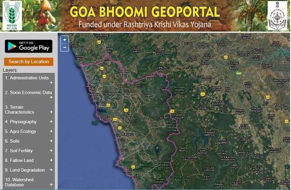
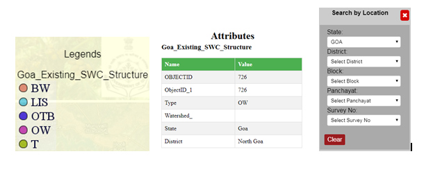
River Stream Drainage Canal, Watershed, Runoff Depth, Runoff Volume) 11.Land Use Planning (Suggusted Agriculture Land Use Planning, Land Management Units) 12.Soil Water Conservation (Existing SWC Structures, Proposed SWC Structures, Proposed SWC Command Area, Areal Soil and Water Conservation Measure) 13.Soil Health Card (dynamic soil health card which is a crop specific and depends on 12 micro nutrients PH, EC, OC, N, P, K, S, Zn, Fe, Mn, Cu, B) This portal also has the Legend information of each layer as well as attribute information of line, polygon and point data also have functionality of zoom in and zoom out and provides the google hybrid satellite view in background. And also provides easy to reach location by clicking search by location button. It filters district, block, village, cadastral.
The App is capable of visualizing, disseminating, sharing and also data mining of the land resources in a digital manner. It derives information from the Bhoomi Geoportal (http://nbsslup.in bhoomi; https://ncog.gov.in/SIS) and stores information on land resources of the state for their easy access by users for agricultural development. The LRIS of Goa has information on: Administrative layers (State Boundary, District Boundary, Taluka Boundary, Panchayat Boundary); Landscape ecology units; soil resources; fallow lands; Command area, Drainage system, Other reference layers and existing and proposed soil & water conservation measures. The novelty of the App is that the client user can view and quarry the information at plot/ cadastral number basis; thereby reaching out to the farmers in a more realistic manner. The App can locate the user's location on hierarchical dropdown selection basis or else the GPS enabled location tracking. The real time GPS based tracking allows the user to collect information while on the go. This also contains query module which allows users (especially planners) to interact and generate dataset for better land use planning. It is also equipped with two Add on Modules that would generate soil health card information and suggested land use plan for the state.
This app derives information from the Bhoomi Geo-portal (http://nbsslup.in bhoomi; https://ncog.gov.in/SIS) and facilitates easy visualization, dissemination and sharing of database on crop suitability and potential crop zone of the country. PCZ mapper displays crop suitability in four categories i.e. S1 (highly suitable), S2 (moderately suitable), S3 (marginally suitable) and N (unsuitable). The suitability assessment programming is purely based on edaphic and climatological variables including rainfall and length of growing period. Further PCZ Mapper displays potential areas in terms HP (Highly potential), MP (Moderately potential), MgP (Marginally potential) and LP (Low potential) for different crop accounting the site specific crop suitability, long term acreage and yield of the crop defined as Relative Spread Index (RSI) and Relative Yield Index (RYI). User clients can also view the related information like soil region, physiography, sub physiography, landform, land management units etc. by clicking the area of interest. The App can locate the user's location on hierarchical drop down selection basis or else. The GPS enabled location tracking is also inbuilt in the App.